Wielkopolska Biblioteka Cyfrowa udostępnia 448 747 obiektów cyfrowych
Obiekt
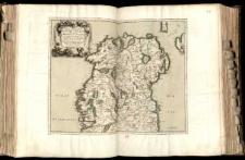
Tytuł: Partie Septentr.le Royaume d'Irlande ou sont la Province d'Ulster, et Partie des Provces de Leinster, et Connaugh; diviees en leurs Comtes &c.
Współtwórca:
Sanson d'Abbeville, Guillaume (1633–1703) ; Cordier, Louis (-1711) ryt. ; Sanson, Nicolas (1600–1667) ; Mariette, Pierre-Jean (1694–1774)
Miejsce wydania:
Opis:
Mapa w atlasie sztucznym, T.1 ; 1 ark. miedz. kolor. powierzchniowo i liniowo 40,1x49 cm na ark. 50,4x70,5 cm ; Mapę ogranicza ramka stopniowa, oznaczona i opisana co 10' ; Mapa pochodzi z atlasu Nicolasa i Guillaume'a Sansonów: "Cartes et Tables de la Geographie Ancienne et Nouvelle". ; Rzeźba terenu przedstawiona metodą kopczykową. ; Tyt. w kartuszu z motywami morskimi.
Język:
Sygnatura:
Wydawca:
Udostępniane przez:
Prawa:
Prawa dostępu:
Digitalizacja:
Sponsor digitalizacji:
Lokalizacja oryginału:
Format obiektu cyfrowego:
Kolekcje, do których przypisany jest obiekt:
- Wielkopolska Biblioteka Cyfrowa > Wielkopolska Biblioteka Cyfrowa - Kolekcja Główna
- Wielkopolska Biblioteka Cyfrowa > Wielkopolska Biblioteka Cyfrowa - Kolekcja Główna > Dziedzictwo kulturowe
- Wielkopolska Biblioteka Cyfrowa > Instytucje współtworzące > Biblioteka Kórnicka PAN
Data ostatniej modyfikacji:
10 paź 2019
Data dodania obiektu:
10 paź 2019
Liczba wyświetleń treści obiektu:
25
Liczba wyświetleń treści obiektu w formacie DjVu
18
Wszystkie dostępne wersje tego obiektu:
https://www.wbc.poznan.pl/publication/564145
Wyświetl opis w formacie RDF:
Wyświetl opis w formacie OAI-PMH:
Obiekty Podobne
Sanson, Nicolas (1600–1667) Mariette, Pierre-Jean (1694–1774) Sanson, Guillaume (1633–1703)
Sanson d'Abbeville, Guillaume (1633-1703) aut. Jaillot, Alexis Hubert ( –1712)
Jaillot, Alexis Hubert ( –1712) Sanson d'Abbeville, Guillaume (1633-1703) aut.
Sanson d'Abbeville, Guillaume (1633-1703) aut.
Sanson, Nicolas (1600–1667) Sanson d'Abbeville, Guillaume (1633–1703) Jaillot, Alexis Hubert ( –1712)
Sanson d'Abbeville, Guillaume (1633-1703) aut. Jaillot, Alexis Hubert ( –1712)

