Wielkopolska Biblioteka Cyfrowa udostępnia 448 527 obiektów cyfrowych
Obiekt
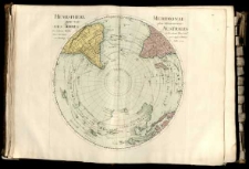
Tytuł: Hemisphere septentrional pour voir plus distinctement les Terres Arctiques.
Współtwórca:
Delisle, Guillaume (1675–1726)
Opis:
Mapa w atlasie sztucznym, T.1 ; 1 ark. miedz. kolor. powierzchn. 46,5x46,4 cm na ark. 52,4x71,6 cm ; Odwzorowanie azymutalne. ; Rzeźba terenu przedstawiona metodą kopczykową. ; Na mapie zaznaczone mityczne obszary: Terre de la Compagnie, Ezo, Cieśninę Vriez.
Miejsce wydania:
Wydawca:
Język:
Sygnatura:
Udostępniane przez:
Prawa:
Prawa dostępu:
Digitalizacja:
Sponsor digitalizacji:
Lokalizacja oryginału:
Format obiektu cyfrowego:
Kolekcje, do których przypisany jest obiekt:
- Wielkopolska Biblioteka Cyfrowa > Wielkopolska Biblioteka Cyfrowa - Kolekcja Główna
- Wielkopolska Biblioteka Cyfrowa > Wielkopolska Biblioteka Cyfrowa - Kolekcja Główna > Dziedzictwo kulturowe
- Wielkopolska Biblioteka Cyfrowa > Instytucje współtworzące > Biblioteka Kórnicka PAN
Data ostatniej modyfikacji:
10 paź 2019
Data dodania obiektu:
10 paź 2019
Liczba wyświetleń treści obiektu:
30
Liczba wyświetleń treści obiektu w formacie DjVu
20
Wszystkie dostępne wersje tego obiektu:
https://www.wbc.poznan.pl/publication/564133
Wyświetl opis w formacie RDF:
Wyświetl opis w formacie OAI-PMH:
| Nazwa wydania | Data |
|---|---|
| Hemisphere septentrional pour voir plus distinctement les Terres Arctiques. | 10 paź 2019 |
Obiekty Podobne
Nolin, Jean Baptiste ( –1708) Cassini, Giovanni Domenico (1625–1712)
Delisle, Guillaume (1675–1726)
Lotter, Matthäus Albrecht (1741–1810)
Sanson d'Abbeville, Guillaume (1633–1703) Cordier, Louis (-1711) ryt. Jaillot, Alexis Hubert ( –1712)
Täubert, H. Homann, Johann Baptist (1664–1724)

