Wielkopolska Digital Library contains 450 213 digital objects
Object
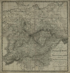
Title: Orographische Uebersicht von Teutschland zu Behufe der Topographisch-militarischen Charte in 204 Blättern davon
Publisher:
Geographisches Institut in Weimar
Place of publication:
Description:
1 ark. ; 39,5x41,4 cm ; Mapa dodana do repertorium innej mapy, wydanej przez Instytut Geograficzny w Weimarze: "Topographisch-militarische Charte von Teutschland in 204 Section unternomen von dem Geographischen Institute zu Weimar 1807" ; Centralny Katalog Zbiorów Kartograficznych w Polsce z. uzup., s. 32, poz. 52
Language:
Rights:
Access rights:
Digitisation:
Location of original object:
Signature:
Object collections:
- Digital Library of Wielkopolska > Digital Library of Wielkopolska > Cultural heritage
- Digital Library of Wielkopolska > Instytucje współtworzące > Biblioteka Kórnicka PAN
Last modified:
Mar 31, 2022
In our library since:
Mar 31, 2022
Number of object content hits:
18
All available object's versions:
https://www.wbc.poznan.pl/publication/601040
Show description in RDF format:
Show description in OAI-PMH format:
| Edition name | Date |
|---|---|
| Orographische Uebersicht von Teutschland zu Behufe der Topographisch-militarischen Charte in 204 Blättern davon | Mar 31, 2022 |
Objects Similar
Röderer, Carl Gale
Röderer, Carl Gale
Boenisch, Johann Gottfried
Torosiewicz, Teodor (1803–1876)
Bönisch, Johann Gottfried Röderer, Carl Gale

