Wielkopolska Digital Library contains 449 841 digital objects
Object
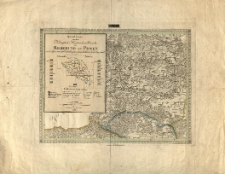
Title: Special-charte von dem Königlich-Preussischen Bezirke der Regierung zu Posen nach dessen neuester Eintheilung in 17 Landräthliche Kreise begraenzt. Sect. 1
Place of publication:
Description:
8,2 cm = 2 mile geograficzne ; 38,7x28,7 cm; ark. 41x31 cm ; 1:180 000 ; mdz. granice kolor. ; Def.: brak ark. nr 7
Language:
Signature:
Publisher:
im Verlage des Geograph. Instituts
Rights Management:
Rights:
Access rights:
Digitisation:
Location of original object:
Digital object format:
Object collections:
- Digital Library of Wielkopolska > Digital Library of Wielkopolska > Regional materials
- Digital Library of Wielkopolska > Digital Library of Wielkopolska > Cultural heritage
- Digital Library of Wielkopolska > Instytucje współtworzące > Biblioteka Kórnicka PAN
Last modified:
Jan 31, 2022
In our library since:
Feb 23, 2006
Number of object content hits:
539
All available object's versions:
https://www.wbc.poznan.pl/publication/14604
Show description in RDF format:
Show description in OAI-PMH format:
Objects Similar
1849
czasopisma
×

